This document presents three distinct big data visualization methods for earthquake catalog data, effectively illustrating the relationships among magnitude, frequency, occurrence time, and epicenter location within large-scale earthquake datasets.
A brief comparison of the advantages and disadvantages of different earthquake catalog visualization approaches is summarized in the table below:
| Method | Earthquake Frequency | Occurrence Time | Epicenter Location | Magnitude | Seismic Hazard |
|---|---|---|---|---|---|
| Traditional Methods | |||||
| 2D/3D Scatter Plot | ○ (shaded) | ✕ | ✓ | ○ (shaded) | ✕ |
| M-T Plot | ○ (shaded) | ✓ | ✕ | ○ (shaded) | ✕ |
| Heat Map | ○ (shaded) | ✕ | ✓ | ○ (shaded) | ✕ |
| Methods in This Paper | |||||
| M-F Plot | ✓ | ✕ | ✓ | ✓ | ✕ |
| M-F Plot Based on RBF Kernel | ✓ | ✕ | ✓ | ○ (shaded) | ✓ |
| Improved M-T Plot | ✓ | ✓ | ✕ | ✓ | ✕ |
Note: ✓: Definitely represented ○: Optionally represented ✘: Not represented

2D Scatter Plot

3D Scatter Plot

M-T Plot

Heat Map
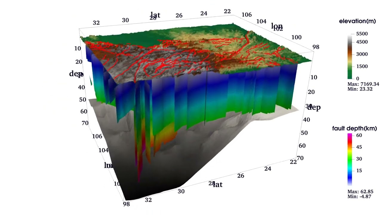
The solid lines in the figures represent the major active faults in the Sichuan-Yunnan region, labeled as follows:
- Daliangshan Fault
- Ganzi–Yushu Fault
- Honghe Fault
- Minjiang-Huya Fault
- Lancang Fault
- Lijiang–Xiaojinhe Fault
- Litang–Batang Fault
- Longmenshan Fault
- Longriba Fault
- Nantinghe Fault
- Nujiang–Ayeyarwaddy Fault
- Weixi–Qiaohou Fault
- Xianshuihe-Anninghe-Zemuhe-Xiaojiang Fault
- China-Burma Fault
(Fault Data Source: Follow this link)

M-F Plot
This plot assesses the damage caused by earthquakes of varying magnitudes, utilizing a visual characterization scheme based on Gaussian kernel functions derived from M-F diagrams.


Function Image

M-F Plot Based on RBF Kernel(1970-2020)

M-F Plot Based on RBF Kernel(2000-2010)

M-T Hotmap
This video integrates over 420,000 earthquake entries of magnitudes 1.0 and above from the Sichuan-Yunnan region, covering the period from 1970 to 2020. It includes data on more than 160 three-dimensional active faults, high-precision topographic information, community velocity models, and the depth of the Moho surface, elucidating the seismic activity characteristics in this region over the past fifty years.
Clone the repository to your local machine:
git clone https://github.com/peixyhe/seismic-catalog_vis_demo.git
cd seismic-catalog_vis_demo-masterThis project relies on several libraries, which can be installed via the environment.yml file. Key dependencies include:
- VTK: For 3D visualization and rendering.
- Pandas: For data manipulation and analysis.
- NumPy: For numerical operations.
- SciPy: For spatial data processing with
cKDTree. - tqdm: For progress bars.
- joblib: For parallel computation.
Install all required dependencies:
conda env create -f environment.yml
conda activate seismic_vis_envRun the desired script. If there are any unclear areas, please refer to the comments regarding the main function in each script. For example:
python ./src/catalog_scatter_vis.py 3D ./rawData/CENC_catalog_1970-2020.csvThis command inputs an earthquake catalog CSV file and outputs a PNG result and a VTK file for further visualization.
python ./src/MT_hotmap_vis.py ./rawData/CENC_catalog_1970-2020.csvThis command also inputs an earthquake catalog CSV file, generating a PNG result and a VTK file.
If this work is useful to you, please cite the following source: He Pei et al., "Seismic Activity Characteristics in Sichuan-Yunnan Region Revealed by Big Data Analysis." This work is currently under review, and specific publication details will be provided upon acceptance.
This project is licensed under the MIT License. See the MIT License file for details.